
Shell Game – photographing the drill rig Kulluk in the Arctic Ocean.
Photographing the Kulluk oil rig connects my long interest in Arctic Alaska, my project World View of Global Warming, and the environmental and societal controversy over energy resources.
In 2012 as I was getting ready to photograph climate science and glacier landscapes in Alaska, I knew Royal Dutch Shell was trying to gain permission to drill for oil in the Arctic Ocean. After documenting the 1989 Valdez oil spill, photography during the late 1990’s at Prudhoe Bay and covering the BP Gulf blowout, photographing oil exploration in Alaska was a natural story for me --- if Shell was allowed to start work. As a conservationist I did not want petroleum companies to expand their oily business into the Arctic Ocean. But if they got their permits, I wanted to photograph it.
Details of Shell’s troubles getting the rigs ready and the issues of sea ice, native whaling and the short summer season in Alaska are well narrated in the NY Times article “The Wreck of the Kulluk.”
In Alaska in July and August with my partner, Dr. Joan Rothlein, I coordinated with environmental groups and followed Interior Department and Shell information releases. The two drilling locations were well known, pinpointed in Shell’s applications and Federal off-shore oil lease maps. One was 70 miles west of Wainwright in the Chukchi Sea; the other very close to the coast east of Prudhoe Bay.
Between shoot locations at Barrow, Fairbanks, Anchorage, Glacier Bay and Kenai Fjords National Parks, I was on the phone and emailing to pilots and flying services trying to find a pilot who could get me out to one or the other site. All but one had reasons they couldn’t, primarily because of the distance to the Chukchi Sea location and their professional relationship with Shell and other oil companies. And Shell was still not ready when we returned home in mid August.
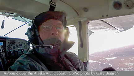
Finally in late September Shell was finally getting in place – but of course the season was already changing up there. Bad weather and short days made planning for an aerial shoot very questionable. I now had funding, mostly from the Alaska Wilderness League, who with Greenpeace and other NGOs had been suing Shell and petitioning Interior to deny the drilling. My one possible pilot had maintenance problems and bowed out on September 27. But at the last moment, thanks to Lighthawk, I found another possible pilot based in Prudhoe Bay at Deadhorse airport. No chance now to get to the western drilling location. I was still negotiating with the Prudhoe Bay pilot when I flew to Deadhorse on October 4.
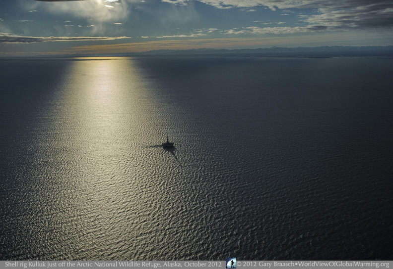
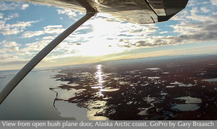
It was cloudy and snowy at Deadhorse airport. The pilot was booked most of the days – which are only 10 hours long. In the afternoon of October 6 he was open, weather was clearing and calm, and we flew east along the Alaska Arctic coast to get a view of the Shell rig’s location. Even though there are scattered oil developments east of the huge industrial oilfield at Prudhoe, the tundra is mostly pristine and there is nothing at this time to be seen over the Arctic Ocean – not even ice. The sea ice cover of the ocean had reached its lowest recorded extent ever less than a month before.
I knew that this most eastern of Shell's two Federal oil lease locations was much closer to land that the more well known one north of the Bering Straits. But as we fly east at about 2000 feet it comes as a shock to be able to soon spot the Shell floating oil derrick Kulluk in the distance. The 160 foot high round rig is anchored above a Federal oil prospect explored in the 1980s and 90s by other oil companies -- but there has been no oil prospecting or drilling in these waters since then.
The rig was in calm seas. No service boats were visible, and no apparent activity on board either. Kaktovik, the nearest Alaska native village is 60 miles to the east. The oil industry already has a huge footprint across more than 50 miles of the central Arctic coast tundra centered on Prudhoe Bay where the Trans Alaska Pipeline begins. Now the shadow of Big Oil falls across these far-northern off-shore drill sites so close to protected land.
As we circled around this drill rig, I was also taken aback by the clear view of the tundra shore and Brooks Range beyond – the Arctic National Wildlife Refuge. That shore, Flaxman Island and the delta of the Canning River was only 12 miles from the Kulluk drilling site. The Arctic Refuge and most of its shoreline are protected from drilling as official wilderness. The area closest to the rig inside the Refuge has been the source of controversy and legislative battles over whether to allow oil exploration there. So far, no drilling has been allowed. Most of the public consider it safe from oil. But here was the Kulluk, an easy drift distance from that coast should a spill or blowout occur.
The next morning dawned clear, and the pilot and I made a long sortie over the rig as the morning sun outlined it and the Refuge in brilliant low light. Waves were higher, and the light more varied and edgy. These are the photos that ended up being so dramatic, published first in The Daily Climate, then by NGOs, and now on the the cover of the NY Times Magazine.
The Arctic Ocean coastal zone is rich with migrating birds, fish and marine mammals, and is also a source of native Inupiat culture and food. Environmental and native groups, long critical of the damage caused by oil production and spills and the role of oil use in global warming, have pressed Interior and the EPA to be more stringent in the permitting process and to disallow ocean drilling because it would degrade air quality and could damage the ocean ecosystem in an oil spill.
Ten groups have argued that there is not enough information about the Arctic ecosystem to make informed decisions about where the least cumulative impacts will occur, that the Clean Air Act has been violated, that a full environmental analysis has been lacking, and that the approved oil spill response plans are inadequate because clean up in the frigid and usually ice-covered Arctic is untested. Many scientific studies are underway on the tundra and in the ocean to try to understand not only the ecosystems, but also the ongoing effects of global warming, which are intensifying in the North. Already scientists can document increased CO2 and methane emissions from thawing permafrost and describe some of the ominous implications of loss of Arctic sea ice for weather and wildlife.
As the NY Times story says, Shell claims it has improved and learned from its debacle in 2012. It decided to scrap the Kulluk, but it has applied for renewed drilling in 2015 and asked for an extension on its Alaska ocean leases. We will soon learn if the EPA, Interior Department and the White House have also learned from 2012… and if Arctic Ocean drilling policy will change.
![]()
COPYRIGHT NOTICE:
Photography and text Copyright © 2005 - 2017 (and before) Gary Braasch All rights reserved. Use of photographs in any manner without permission is prohibited by US copyright law. Photography is available for license to publications and other uses. Please contact requestinformation@worldviewofglobalwarming.org. View more of Gary Braasch's photography here.